Rebranding and common misspellings can often lead to confusion.
Two words that are often misspelled are contained in the new name for the Port Covington urban development project in Baltimore, Maryland on the south shore of the South Baltimore peninsula. That name, of course, as the title of this article indicates, is Baltimore Peninsula.
Port Covington is the geographic area of Baltimore’s strip of land along the Middle Branch of the Patapsco River on the southern edge of the South Baltimore peninsula. Over a century ago it was developed as a port for the shipment and export of coal. It is (today) the site of one of the largest urban development projects on the East Coast.
The port of Port Covington circa 1913 on the south shore of the Baltimore Peninsula.
In today’s business world, rebranding is becoming increasingly popular. However, with rebranding comes the risk of misspellings. While careful proofing eliminates errors in marketing materials many people (marketing agencies) fail to consider typos by the general public – especially when typing Internet domain names into the URL bar of a web browser.
The Port Covington urban development initiative has been rebranded to the name Baltimore Peninsula. (Note: the red text was added by the photographer to illustrate the rebranded name.)
So, what about the misspellings of Baltimore Peninsula?
Common typos for “Baltimore” are balitmore (59%), balitimore (7%) and baltimroe (5%). Common typos for “peninsula” are penninsula (54%), pennisula (19%) and penisula (18%).
Note: the percentages shown are from the How to Spell website and were collected from over 15,231,521 spell check sessions on www.spellchecker.net from Jan 2010 – Jun 2012.
There are people (and companies) who capitalize on misspellings when it comes to recovering website traffic. They are commonly referred to as “domain squatters” and actually do monetize erroneous web traffic. Yes, people really do type in web addresses and often type them incorrectly. Of the above examples (as of this writing, November 2022), baltimroe.com is still available – the others have all been registered by someone or some entity. A couple are being offered on the third-party market and one has expired and may soon be deleted from the registry (perhaps for someone else to grab). This writer will be surprised if “baltimroe.com” is not soon registered.
From those typo percentage it might be interesting to see how long the domain “BalitmorePenninsula.com” and its variations remain available. (Yes, that is meant as a hint to the marketing agency responsible for the BaltimorePeninsula.com website. 🙂
Street level view of the Baltimroe Penisula (sic) urban development project on the south shore of the South Baltimore peninsula.
The new “branding” for Port Covington is now the Baltimore Peninsula.
We’re thinking the new developers (from New York and San Francisco) may not understand the actual geography of a peninsula. The South Baltimore Peninsula, Baltimore’s peninsula, is the land between the Inner Harbor and Patapsco River on the north to the Middle branch of the Patapsco River on the south. It is so much more than the narrow piece of land south of Interstate 95, the area known as Port Covington, on the south shore of the peninsula.
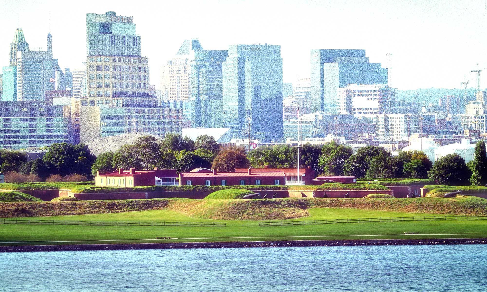
Here is a nearly two-decade old photo of the “Baltimore Peninsula” as seen from the Harborview Condominium tower in 2004. The water in the foreground is the Inner Harbor/North Branch of the Patapsco River. The water in the top right is the Middle Branch of the Patapsco River. This is “the” peninsula as defined by geography and the people and businesses living and thriving here.
Port Covington nearly a decade ago. The photograph is from the deck of a cruise ship departing the Cruise Maryland Terminal on January 31, 2014.
Regardless of the thinking or the geography, having a proper domain name is certainly better than the PC.city (dot-city) domain that was used for the last few years. The new Baltimore Peninsula actually uses baltimorepeninsula dot-com as the URL address. The old PC.city and PortCovington.city now redirect to the new domain and website. We’ll award kudos for that part of the change.
It is what it is and we sincerely wish the best for the developers and hope that the project moves forward rapidly and successfully. The impressive amount of new urban development will be beneficial for all of the people of Baltimore and for the communities surrounding the Baltimore Peninsula.
Now on to the humorous part of the rebranding.
Of course, any radical change brings forth the humorous memes on Social Media. One of the most creative is from the talented people at the website called Baltimore Memes.
This will be completed soon….or not…to include the basic tenets of the main meme and various “rebranding” comments gleaned from Facebook and Twitter.
Well, OK, here’s one: National Aquarium = Place with All the Fishes and another: Little Italy = PastaVille and one more: Fells Point = Cape Beer
If you have another – please post in the comments.
A recent panorama photograph or the South Hanover Street Bridge to the west of Port Covington, now Baltimore Peninsula. This bridge connects South Baltimore with Curtis Bay, Brooklyn Park, Glen Burnie and other points to the south. Yes, this photograph is available as wall art.
A brief History of the Peninsula, or SOBO or South Bmore, as you like.
The peninsula of land south of the Baltimore Harbor, between the Northwest and Middle branches of the Patapsco River, has a long and colorful history. The strategic importance of this peninsula became apparent during both Wars for Independence.
Lord Baltimore granted the first land patent on the Baltimore peninsula to Charles Gorsuch in 1661 for the yearly rent of one pound sterling. This patent was for a 50-acre tract of land that is today known as Locust Point. Gorsuch later abandoned the land, and in 1702 James Carroll received a patent for the same tract, which was then called Whetstone Point. Carroll paid a rent of 2 shillings per year.
The next tract of land on the peninsula to be patented was Upton Court, a 500-acre tract next to Whetstone Point that was patented by David Poole in 1668. Four years later, in 1672, David Williams received a patent for 100 acres next to Upton Court which he called David’s Fancy. This land was between Upton Court to the east and land owned by John Howard to the west. Despite these patents, the peninsula remained unoccupied during the first two decades of the 18th century.
In 1723, John Giles obtained a Certificate of Resurvey to Upton Court and in 1725 consolidated it with Whetstone Point, which he had obtained from James Carroll for 5 pounds sterling. Giles sold 400 acres of this land 2 years later to the British Principio Company, along with the rights to all the iron ore found there, for 300 pounds sterling and 20 pounds current money of Maryland. (The Principio Company was an association of British iron-masters engaged in manufacturing pig and bar iron. It had been operating an iron furnace 20 miles to the north on the Great Falls of the Gunpowder River since 1715. Whetstone Point for many ears was to one of its principal sources of ore.) Several years later, Jacob Giles, heir of John Giles, sold the remainder of Upton Court to John Moale. When Moale found David’s Fancy vacant, he also claimed that land and opened a mine.
Details of the South Baltimore peninsula – Baltimore Inner Harbor to Locust Point
In 1732, Richard Gist received a patent for an alluvial deposit at the foot of Lunn’s Point. This area was known as Gist’s Inspection, but is better known today as Federal Hill.
In 1737, John Moale obtained a Warrant of Escheat to David’s Fancy. (Lord Baltimore had a right of escheat when a patentee died without a will or heirs. In a wilderness populated by semi-literate people without known relatives, this occurred frequently.) He ended up sharing ownership of most of the peninsula between the Northwest Branch and the Middle Branch of the Patapsco River with the Principio Furnace Company and Richard Gist.
The importance of Whetstone Point for the defense of Baltimore became apparent when the Revolutionary War began. Maryland expropriated the British Principio iron works on Whetstone Point and used these facilities to aid the American war effort. In 1775, preparations began to fortify the area. A water battery of 18 guns was placed on Whetstone Point. A chain was stretched across the neck of the harbor, supported by 21 sunken schooners. An air furnace was also built near the batteries to provide munitions. When the Revolutionary War ended, the Free State confiscated 195 acres of land belonging to the company and sold the land at auction.
These fortifications remained under Maryland control until 1793, when Congress passed a resolution which stated: “…the United States may think it necessary to erect a fort, arsenal, or other military works or buildings on Whetstone Point….” However, Congress did not see fit to provide adequate funds; it was the citizens of Baltimore who made up the deficiency.
Built strategically at the mouth of the Baltimore Harbor, Fort McHenry earned its place in history during the final months of the War of 1812. In September 1814, the British had turned their sights toward Baltimore after sacking and burning Washington. The British were intent on punishing Baltimore because it was home port for a large number of privateers–privately owned, armed ships sailing under government commissions–which had been harassing British shipping throughout the “Second War for Independence.” Baltimoreans did not stand idly by in the face of this threat. They armed themselves and built heavy defenses around the city; Fort McHenry was a crucial element in this defense. British strategy called for their ships to blast their way past Fort McHenry. As all proud Baltimoreans know, the British failed. At the end of the 25-hour bombardment, Francis Scott Key wrote the memorable poem which later became the national anthem. The fort still proudly stands on Locust Point, an attraction for visitors from across the globe and a symbol of the American spirit.
Interesting Facts about the South Baltimore Peninsula:
During Colonial period, there was a horseracing track on Whetstone Point.
An observatory was constructed on Federal Hill in the late 18th century. In 1797, David Porter notified the city that his observatory on Federal Hill was ready. Patrons could obtain a year’s admittance for $3.00 or each visit was 25 cents. This observatory, subsequently known as the Signal Service Observatory, identified approaching ships and provided the information to those involved in commerce.
Several ferry companies operated from Locust Point. The “Locust Point Ferry Company” was formed in 1851; its route was from Kerr’s Wharf to Locust Point; in 1857, the terminus changed from Kerr’s Wharf to the lower end of Broadway. In 1865 the Patapsco Company opened a ferry from Locust Point to Ferry Bar.
In 1854, the “Federal Hill Steam Ferry Company” was organized. Its route was from Hughes to West Falls Avenue.
In 1865, some prominent Baltimoreans, assisted by the Baltimore and Ohio Railroad, inaugurated the first steamship line between Baltimore Harbor and Liverpool using old steamships purchased from the Federal Government. In 1870, the Allan Line was established between Liverpool and Baltimore.
In 1865, M. E. Uniack opened a ferry with 20 small boats to transport people from Covington Street to the tobacco warehouse on the opposite side of the harbor.
In 1868, the B & O Railroad Company signed a contract with the North German Lloyds to establish the first steamship line between Baltimore and Bremen, Germany. The B& O built piers at Locust Point to receive the stream of immigrants arriving from Europe. Although many remained in Baltimore, many other immigrants immediately boarded the B&O trains and headed for points west. Thus, Locust Point was the first American soil walked on by countless thousands of European immigrants.
In 1874, the first dry-dock ever constructed in Baltimore was built at Charles Reeder’s wharf at the foot of Hughes Street, on the south side of the basin.
In 1877 the Baltimore Dry Dock Co. was incorporated. This company successfully got a bill through Congress granting a portion of the Fort McHenry tract for the construction of “Simpson’s Improved Dry Dock” on that tract. In return, U. S. Government ships were to dock free at that location.
Bibliography:
Garrett Power, Parceling Out Land in Baltimore, 1632-1796, published by the Maryland Historical Society.
J. Thomas Scharf, History of Baltimore City and County, published 1881 in Philadelphia, PA